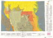
Geologic map showing the thickness and structure of the Anderson-Wyodak coal bed in the north half of the Powder River Basin, southeastern Montana and northeastern Wyoming
« Previous
|
Next »
(Image
of 1)