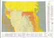
Geologic map showing thickness of sedimentary rocks from groundsurface to the top of the upper Cretaceous Pierre Shale in the north half of the Powder River Basin, southeastern Montana and northeastern Wyoming
« Previous
|
Next »
(Image
of 1)