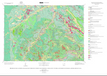
Preliminary Digital Surficial Geologic Map of the Devils Tower 30’ x 60’ Quadrangle, Crook County, Wyoming, and Western South Dakota, Southeastern Montana (2001)
« Previous
|
Next »
(Image
of 1)