 Loading... Please wait...
- (307) 766-2286
- Home
- My Account
- View Cart

Wyoming State Geological Survey Publications Sales and Free Downloads
WSGS Main Website: www.wsgs.wyo.gov- Home
- Publication Type
- USGS Miscellaneous Maps
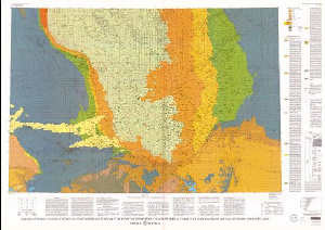
- Geologic map showing thickness of sedimentary rocks from the ground surface to the top of the upper Cretaceous Pierre Shale in the south half of the Powder River Basin, northeastern Wyoming and adjacent areas
Geologic map showing thickness of sedimentary rocks from the ground surface to the top of the upper Cretaceous Pierre Shale in the south half of the Powder River Basin, northeastern Wyoming and adjacent areas
$9.00
SKU:
USGS-1995-I-2433-B
Current Stock:
8
I-2433-B Geologic map showing thickness of sedimentary rocks from the ground surface to the top of the upper Cretaceous Pierre Shale in the south half of the Powder River Basin, northeastern Wyoming and adjacent areas, scale 1:200,000, 1995, ISBN 978-0-607-79592-9 Keywords: Powder river basin, Stratigraphic Geology, Stratigraphy, Geologic maps, Sedimentology, Sedimentary and carbonate rocks
